Kew Golf Club

ISimpson's Lake (May 2015)
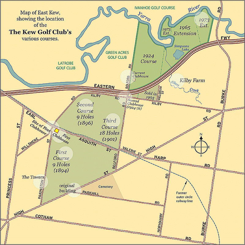
LOCATION
The Club's main entrance is in Belford Rd, East Kew, across the Eastern Freeway Bridge. It extends easterly to the Burke Rd Billabong Reserve - its northern boundary is the Yarra, and on the west it's adjacent to the Greenacres Golf Club.
The Main Yarra Trail is squeezed between the Freeway crash barrier and the Golf Course fence.
HISTORY
1894
The Kew Golf Club is Melbourne's third oldest golf club was formed by James Anderson, a solicitor, and Fred Fitts, an architect, to provide golfing facilities for the residents of Kew and Hawthorn.
The first course was laid out on leased land about 1km south of the present site. It was just south of the Old Outer Circle Railway and was designed by Richard Taylor, Australias first golf professional.
The first clubhouse was on the south side of Asquith Street, near the corner of Willsmere Road.
1896 - 1899
The course was extended to the north of the Railway oin 1896 and further to the east in 1899 till it occupied much of the land in the area bounded by Asquith Street, Belford Road and Willsmere Road.
1916
The club lost much of its land to a housing sub-division and struggled for a few years with an inadequate layout.
1922
A huge step forward was made when the first freehold land of 92 acres was purchased on the corner of Belford and Kilby Roads, extending to Meldrum Street in the east and all the way to the Yarra in the north. Club professional Jock Robertson and Jock Young laid out the new course on the Yarra River Flats and despite occasional inundations, the Club entered a new era of consolidation and advancement that was underpinned by a long period of staff stability. A fine clubhouse was constructed (later extended) which stood for more than 40 years.
1960
The Club learned that it was to lose part of its course to the proposed Eastern Freeway. The next few years saw considerable change. Land fronting Kilby Road was sold and the course was completely redesigned and rebuilt, being extended in the east across Glass Creek. No sooner was this work finished than the Board of Works announced plans for an expanded Freeway, which was to cut right through the clubhouse. Another major redesign was required. Further land was acquired in the east that included the present fourth and sixth greens and in the Yarra River loop where the fifth and sixth tees stand today.
The Club was also able to acquire a triangle of land through which the second fairway now passes (the Grant Hay Triangle) which it had sought for many years.
1970s
After a decade of inconvenience and two reconstructions, the modern clubhouse and fine course had been built.
1999 - 2002
Between 1999 and 2002 the clubhouse was progressively updated.
PRESENT DAY
The clubhouse was built in 1972 and has a dominant view of the course and Yarra Valley. The course is acknowledged as among the best clay belt courses in Victoria. Its strength lies in the use of the natural water lakes and billabongs. Glass Creek and the Yarra River have all been incorporated into a layout of great natural beauty with water birds abound. Dusky moorhen, purple swamp hen, pacific black duck, maned (wood) duck, chestnut teal and eurasian coot can be seen every day.
GLASS CREEK
Glass Creek is a waterway flowing through the inner-eastern suburbs of Melbourne. It is a minor tributary of the Yarra River and now largely runs through a series of underground drains.
The creek was named after Hugh Glass, a land speculator in the early history of Melbourne, in 1844.
In the early history of Melbourne and during the indigenous settlement of the area, Glass Creek ran at-surface through what was then bushland. William Oswin is the first recorded owner of the land where Hays Paddock and Glass' Creek flows into the Yarra on a property known as Kilby Farm.
The first proposal to route the creek underground in its northern section was put forward by the City of Kew town clerk, W.D.Birrell, in 1943, but the project was not pursued. The exact date of the rest of the creek's re-routing through the underground drainage system is unknown, but a Melbourne and Metropolitan Board of Works map from the 1960s shows the creek entering the present-day drain near the southern entrance of Hays Paddock.